

BirdNET Live Review: Professional Bioacoustics for Your Local Patch
BirdNET Live brings structured acoustic surveys, automated species detection and research-compatible exports to an ordinary phone. Its clear interface makes a substantial professional toolkit accessible to patch birders—but reliable monitoring still depends on the method behind it.
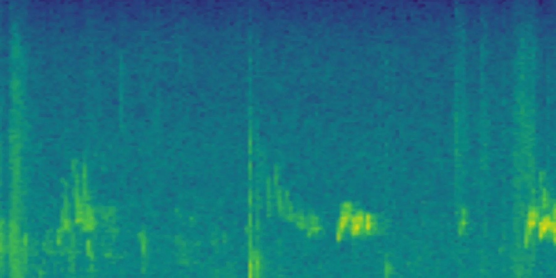
A BirdNET Live spectrogram from a patch survey.
BirdNET Live is a free, open-source bioacoustic field package for Android and iOS. It combines continuous sound analysis, timed point counts, route-based surveys, file analysis, session review and export in formats used by sound researchers. The interface is easy to follow, but this is not a simplified identification app. Its developers describe it as ‘professional bioacoustics in your pocket’. It is aimed at conservation professionals, researchers, students and ambitious citizen scientists.
Bioacoustic monitoring uses recorded wildlife sound to study which species are present, when they are active and how detections change between places or dates. The recording can be collected without an expert listening to every second, while a sound classifier reduces many hours of audio to a list of passages worth examining. This makes longer and more frequent surveys possible, but it does not remove the need to design the survey or check its results.
For a patch birder, that is BirdNET Live's appeal. A phone can record the same route or fixed point each week, attach times and locations to detections, preserve selected evidence and export the session. Instead of watching an identification screen throughout the walk, the observer can review the survey afterwards and concentrate on unusual, important or doubtful records.
Apps like Merlin Sound ID serve a different purpose. It is mainly an identification companion, supported by photographs, maps, reference sounds and species accounts. BirdNET Live can also suggest a bird in real time, but its distinctive value is the structured record left after listening ends.
BirdNET Live is built around survey workflows
The app’s modes show how its developers expect it to be used.
| Workflow | What it does | Patch use |
|---|---|---|
| Live Mode | Analyses incoming sound and displays detections immediately. | Checking the system, following current activity or investigating a sound. |
| Point Count Mode | Runs a timed, uninterrupted stationary survey and saves the result. | Repeating short counts at fixed locations. |
| Survey Mode | Records a long moving transect with GPS, background monitoring and detection sampling. | Repeating a patch route and mapping where sounds were detected. |
| ARU Mode | Runs scheduled recording cycles at a fixed site. | A possible route towards a dedicated autonomous station; still an early implementation. |
| File Analysis | Processes an existing recording with chosen date, location and analysis settings. | Rechecking retained audio or analysing recordings made elsewhere. |
| Session Review | Combines playback, spectrogram, mapped detections, corrections and export. | Turning raw model output into an examined survey record. |
This is a complete field-to-review workflow. The sound and geographical models run on the device, so the core analysis works without mobile reception. Sessions can remain local, and no account is required. Optional map, place-name and weather services connect to external providers only when enabled.
The package is also designed to preserve provenance. Its exports can include the app and model versions, settings used, timestamps, locations and audio. That information matters when a survey is repeated or another person needs to understand how the result was produced.
BirdNET Live separates immediate listening, stationary point counts, moving surveys and scheduled recording into distinct workflows.
The surveys are automated, but normally attended
Survey Mode automates recording, analysis and logging during a walked transect. The observer is still present and decides the route, duration, phone position and field notes. Point Count Mode does the same at a stationary location and stops automatically after the chosen time.
Genuinely autonomous monitoring is a separate commitment. BirdNET Live has an ARU Mode for scheduled fixed-site recording, but the developers call it an early implementation, with iOS background behaviour still awaiting field validation. A long-term installation would normally need a dedicated phone or base-station device, continuous power, a fixed microphone and weather protection.
What a patch survey can measure
A repeat acoustic survey can answer useful questions:
Is a target species detected at this point or along this route?
On what proportion of comparable visits is it detected?
When is a migrant first or last detected during the season?
Which sections of the route produce detections?
How does the detected bird community change from month to month or year to year?
It cannot count birds simply by counting detections. One nearby Robin may call often enough to create dozens of records, while several silent birds create none. Detection totals describe the activity reaching the microphone, not the number of individuals present.
A repeatable method matters more than the longest list
BirdNET Live makes collection easy, but comparisons are only useful when the method remains reasonably stable. Keep the following consistent:
route or point location;
start time and duration;
direction and walking pace on a transect;
phone, microphone and carrying position;
confidence, sensitivity, inference and geographical-filter settings;
recording method and audio format;
GPS sampling interval;
app, audio-model and geographical-model versions.
Note wind, rain, traffic, leaf cover, disturbance and changes to the habitat. These conditions alter what reaches the microphone. The same applies to a phone moved from an exposed shoulder strap into a coat pocket: the survey method has changed even if every software setting is identical.
The app supports this discipline. Survey setup records a name, transect, observer, location and parameters. Observers can add manual sightings or sounds during the survey. When it ends, the route and detections move to Session Review, where the observer can listen, examine the spectrogram, confirm or replace identifications, remove errors, and export the result.
Accuracy is a property of the survey, not a single score
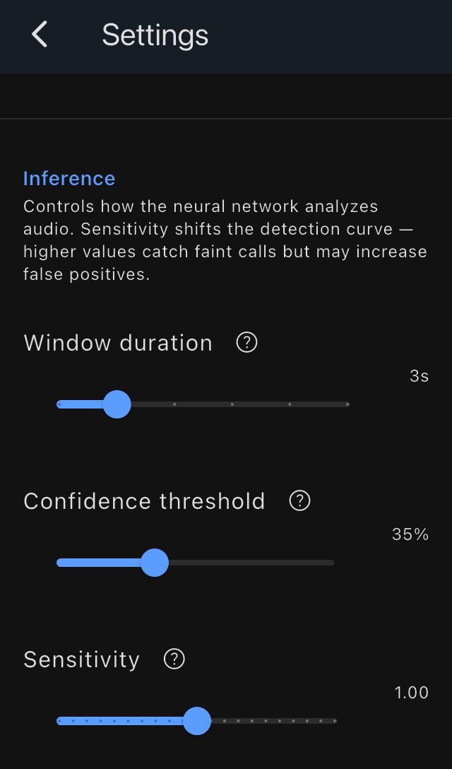
Window duration, confidence threshold and sensitivity change what the app displays and therefore form part of the survey method.
BirdNET Live’s official FAQ says detections above 70% are generally reliable. It also states that performance depends on the species, recording quality, distance and background noise, and that rare species should be verified visually. The project’s acceptable-use policy goes further: model predictions may contain both false positives and false negatives and should be distinguished from verified biological observations.
Early field reports make the same point. A team using Survey Mode during the 2026 DDA BirdRace found it practical in field conditions, but reported frequent false positives, including some above 70%. That test preceded the present release and several of its requested review features have since been added, so it should not be treated as an accuracy estimate for the current model. It does show why a confidence threshold cannot replace local validation.
Research using other BirdNET workflows has found that results change substantially with confidence thresholds and that the best threshold can differ between species. A 2025 comparison in Munich found that BirdNET could perform as well as expert acoustic review under the tested conditions. For a presence-and-absence list at a familiar site, the researchers suggested checking the strongest results for each species, removing species detected only once or twice, and manually reviewing uncommon or infrequently detected species. They also stressed that their thresholds came from one urban site and might not transfer to other habitats or regions.
For a personal patch inventory, that need not mean checking every common detection forever. Review the system closely at the beginning, learn its recurring errors and check a sample of expected species. After that, concentrate effort on anomalies, low or isolated detections, important target species and any result that conflicts with field observation. Recheck the method after a change of phone, microphone, season, habitat or model.
Geographical filtering is part of the survey design
BirdNET Live uses a separate geographical model to estimate which species are likely at the location and time of year. Its settings guide offers four approaches:
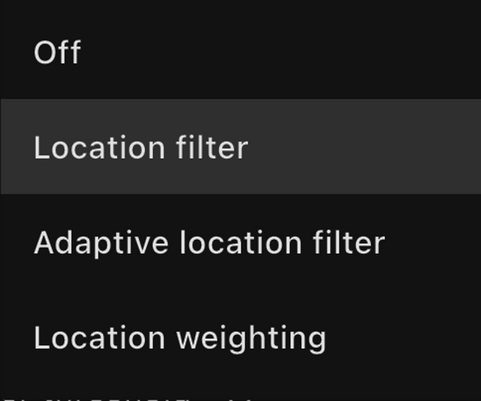
BirdNET Live can exclude, raise the threshold for or down-weight species that its geographical model considers unlikely.
| Species filter | Effect on the survey |
|---|---|
| Off | Keeps acoustically eligible candidates without geographical filtering; more anomalies must be checked. |
| Location filter | Removes species below a chosen geographical threshold. |
| Adaptive location filter | Demands stronger acoustic evidence as a species becomes less likely locally. |
| Location weighting | Uses local likelihood as an additional influence rather than a simple exclusion. |
For routine monitoring, filtering is a strength. It prevents a long session from filling up with weak suggestions of species that shouldn’t be present. An hour or two of mostly automated recording can then produce a manageable review list rather than a catalogue of every speculative match.
I ran my first two long patch sessions without deliberately changing the downloaded settings. The displayed species formed a convincing inventory of the birds present, and I found no listed species that I would reject after review. That is an encouraging field result, not an accuracy rate. Few birds were singing, missed species were not measured, and the exact public filter label used by the installed configuration was not recorded.
Playback tests showed how much the geographical model can matter. Recordings of locally expected birds at the appropriate time of year were accepted repeatedly; recordings of species not expected there were ignored until the filtering was changed. The audio had not changed. The survey question had.
That behaviour is desirable if the aim is an accurate inventory of the normal patch community. It is a problem if the purpose is to find a first arrival, range expansion or rarity. The official guide says Adaptive filtering can require an acoustic score of roughly 0.92–0.97 for a species absent from the local list, although a score of 0.99 or above is retained regardless.
The filter should therefore follow the question:
| Survey purpose | Recommended principle | Review burden |
|---|---|---|
| Routine community monitoring | Use one locally tested filter consistently. | Check anomalies and sample expected detections. |
| Repeated target-species survey | Confirm the target is allowed through and retain its audio. | Check every target detection and a sample of non-detections. |
| First arrivals or unusual species | Reduce geographical exclusion and retain the full recording. | Expect many more candidates. |
| Reportable rarity | Treat the app as a detector, not the evidence standard. | Obtain clear audio and, where possible, visual confirmation. |
The important distinction is between survey accuracy and proof of a single exceptional record. A well-filtered survey may give a dependable picture of familiar species while deliberately making rare candidates harder to find.
My Treecreeper result: acceptable for a survey, insufficient for a rarity
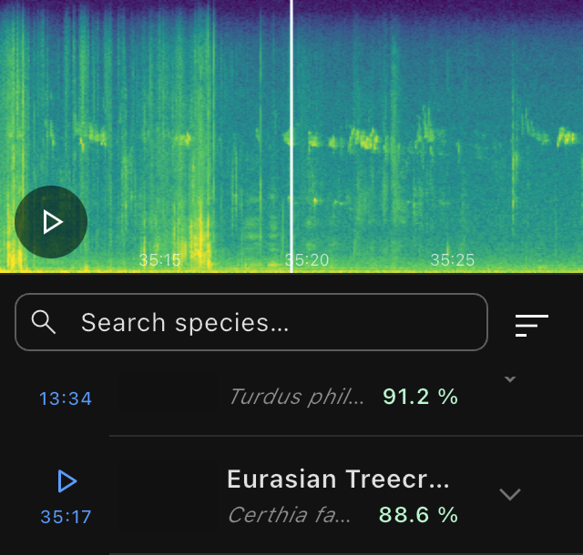
BirdNET Live scored this Eurasian Treecreeper passage at 88.6%. It was plausible for a routine patch survey, but the recording was too weak to support an equivalent rarity claim.
One test session contained an 88.56% Eurasian Treecreeper detection. I did not see or consciously hear the bird at the time. Eurasian Treecreepers are regularly present on this patch, so the result fit the habitat and repeated field experience. The retained passage was nevertheless too weak for confident human identification from the sound or spectrogram alone.
For a routine patch survey, I would retain it as a probable detection. I would not accept the same recording as evidence of Short-toed Treecreeper, which would be unusual but not impossible for the location. That claim would need a much clearer recording and preferably visual confirmation.
This is not inconsistent. The risk attached to the decisions is different. A normal community survey can tolerate a small and measured classification error. A rarity report, threatened-species decision or management action requires stronger validation.
Long recordings need a planned review method
Survey Mode includes detection sampling because a long session can generate thousands of records and clips. The app can retain all clips, the highest-scoring examples for each species or a spatially distributed selection. The detection log remains even when a clip is discarded.
This is more than a storage convenience. Keeping the best examples of common species lets you check a survey without saving every Robin call. Keeping the full recording is safer when the aim includes scarce targets, first arrivals, or sounds the model may have filtered out.
A practical review sequence is:
Check every unexpected, conservation-relevant or first seasonal species.
Check species represented by only one detection.
Check results close to the chosen threshold.
Check anything that contradicts what was seen or heard.
Sample common species to find locally plausible false positives.
Add birds recorded by the observer but missed by the model.
Mark confirmed records and export the reviewed session.
Session Review is one of the app’s strongest features. Detections are grouped by species and can be sorted, searched, played, corrected, deleted or confirmed. Survey records can be examined on the route map. The confirmation flag and manual seen/heard evidence pass into the exported data.
Early forum comments repeatedly identify this review layer as a major advance. An iNaturalist user valued being able to find every passage assigned to a species and remove noise misidentified as birds. BirdForum contributors praised file analysis and the survey modes, but reported problems from traffic or handling noise and wanted clearer advice for inference and geographical settings; one found that an external microphone improved results on their phones. In the project’s GitHub discussion, another user singled out the interface and export options. These are individual reports, but they match the app’s intended strength: it does not merely produce a name; it gives the user control of the record.
The data are usable beyond the phone
BirdNET Live can export Raven Selection Tables, CSV, JSON, GPX and a ZIP bundle with selected audio and an HTML report. Exports can include the app version, model, settings and other provenance data. That makes the result suitable for further analysis and allows later visits to be compared on the same basis.
CSV is the easiest starting point for a personal patch spreadsheet. Use one row per survey for the date, start time, duration, route, weather, settings, model version and notes. A second table can hold one row per species per visit: detected or not detected, number of accepted detections, number checked, first and last time, and evidence notes.
The app does not convert its detections into verified eBird or BirdTrack records. Submit only records you have reviewed. If a conservation organisation, records centre or research project may use the data, agree the survey method and validation requirements before collecting a large dataset. A professional export does not by itself make the protocol suitable for every institutional purpose.
Battery, heat and storage are real field costs
On-device inference is computationally demanding. BirdNET Live’s documentation says warmth and battery use are normal during real-time analysis. In one 20-minute test on an iPhone SE running iOS 26.6, the battery dropped by 8%, and the phone warmed up while BirdNET Live and eBird ran together. That test cannot separate the two apps, but it represents a realistic field combination.
For a full day, carry a power bank and the correct cable. Lower inference and GPS rates may save power, but they change the survey: lower inference leaves wider gaps in the analysis, while longer GPS intervals reduce route detail. Record any change when visits will be compared.
Full recordings also need storage. One 47-minute-41-second mono FLAC file examined for this review occupied about 104 MB, equivalent to roughly 130 MB per hour for that soundscape. FLAC size varies, but a season of repeat surveys needs a filing and backup plan.
The limitations of a rapidly developing package
BirdNET Live is under active development. That brings improvements quickly, but it also means documentation and store listings can move at different speeds. At the time of checking, the documentation described Batch Analysis as still under development even though app-store copy listed it among the workflows. ARU Mode was explicitly labelled an early implementation, and its background behaviour on iOS remained unvalidated.
The app and model versions should therefore be recorded with every serious survey. The tests for this review used BirdNET Live 1.1.2 build 223, BirdNET+ V3.0-preview3.1, Geomodel V3.0.4 and taxonomy v0.2-jun2026.
Forum experience is still limited because the app is new. Reports differ on sensitivity, false detections, battery use and microphones. That is expected: phones, habitats, sound levels and settings differ. Early comments help you find questions to test, but not to declare an overall accuracy rate.
Verdict: a professional survey tool made accessible
BirdNET Live is not simply an alternative way to identify a calling bird. It is a substantial bioacoustic package that collects, organises, reviews and exports acoustic survey data on a phone. Its interface makes these functions approachable without sacrificing professional depth.
For a patch birder, Survey Mode and Point Count Mode are the strongest uses. They can automate much of the logging, produce an accurate working inventory after local checking and build a comparable record across a season. Permanent unattended monitoring is better treated as a later project built around a dedicated station.
The best results will come from deciding the question before changing the settings. Use geographical filtering to control routine error, check its effect on every target species, retain enough audio to audit the result and apply a stronger evidence standard to rarities or consequential records. Used in that way, BirdNET Live brings serious bioacoustic monitoring within reach of an ordinary patch birder.
Testing and disclosure
This review is based on several autumn patch sessions, playback trials, direct inspection of one exported BirdNET Live session and review of supplied audio files. The inspected export was a 47-minute-41-second Live Mode session containing 19 detections of 10 species; it was not a Survey Mode export. The sessions were not controlled accuracy trials and did not measure false negatives.
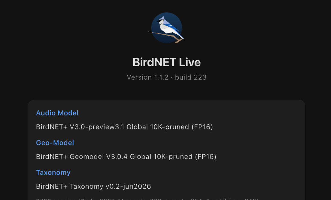
The review used BirdNET Live 1.1.2 build 223 with BirdNET+ V3.0-preview3.1 and Geomodel V3.0.4.
The app was downloaded normally. There was no payment, loan, sponsorship or contact with its developers.
Sources and further reading
App documentation, research links and forum reports checked 3 September 2026.